
Geospatial intelligence for decisions on the ground in Indonesia
We simplify satellite data and territorial sensors into clear, actionable intelligence, enabling corporate management and public policymakers to act decisively on ground truth.
From Orbit to Field to a Decision
We combine global satellite constellations, UAV drone surveys, and specialized Geo AI pipelines into intuitive tools your teams already understand.
Multi-Source Remote Sensing
Sentinel-1 radar, Sentinel-2 optical, Landsat historic archives, climate grids, high-precision UAV drone photography, and field GPS ground points.
Modeling & Analytics
Vegetation indices (NDVI/EVI), automated canopy cover classification, multi-temporal change detection, and predictive hazard susceptibility matrices.
WebGIS & Donor Audit Reports
Interactive cloud dashboards without recurring software fees, M&E audit trails for international funders, and regulatory compliance dossiers.
"Environmental and disaster management decisions require verified location data. We established PT Inklusi Teknologi Strategis so advanced geospatial analytics and AI can be used directly by public agencies, corporations, and non-profit organizations without software barriers or technical friction."
Critical Ground Challenges We Solve
Nature-based solutions and disaster risk reduction require auditable spatial evidence, not rough approximations.
"Do you know exactly which micro-zones in your district face the highest landslide risk this monsoon?"
Correlating slope angles, precipitation anomalies, and terrain mobility history produces actionable hazard zoning layers for contingency planning.
"What percentage of planted tree saplings have actually survived after 6 to 12 months?"
Multi-temporal vegetative indices (NDVI/EVI) establish empirical proof of canopy recovery, providing donor-ready verification records.
"How rapidly has forested canopy shrunk in your conservation buffer zones year-over-year?"
Geo AI change detection identifies forest clearance and agricultural conversion early, enabling rapid park ranger interventions before irreversible damage occurs.
"How do you demonstrate ecological recovery to international funders with irrefutable proof?"
Consolidating multi-sensor hydrological indicators, vegetative density, and wildlife corridors into interactive donor reporting portals.
"Are the geospatial datasets in your statutory compliance filings auditable and fully up-to-date?"
Structured spatial databases compliant with Indonesian Geospatial Information Agency (BIG) standards, ensuring smooth statutory verification.
Planning an Environmental or DRR Program?
Every effective nature-based initiative begins with accurate spatial intelligence. Discuss your program scope with our specialists.
We Also Partner with Broader Commercial Industries
Our spatial analytics and Geo AI algorithms apply seamlessly to commercial enterprise challenges, agricultural optimization, and asset tracking.
Standard Industrial Classifications (KBLI)
Operating under verified Indonesian Standard Industrial Classifications (KBLI), ensuring complete statutory compliance for government tenders and multilateral donor grants.
Environmental & Disaster Spatial Analysis
Multi-temporal satellite and drone analytics for land cover change monitoring, hazard susceptibility modeling, and habitat rehabilitation suitability.
Custom WebGIS & Spatial App Development
Building interactive spatial dashboards for tree survival monitoring, daily incident reporting, and open API integration without recurring seat licenses.
Strategic Spatial Consulting
Preparation of statutory spatial dossiers: Strategic Environmental Assessments (KLHS), Disaster Risk Assessments (KRB), and corporate ESG compliance audits.
Geospatial Capacity Building & Training
Comprehensive training workshops on open-source GIS (QGIS), Google Earth Engine cloud computation, and participatory mapping for local field units.
Complex Spatial Data, Human-Language Decisions
Corporate executives, public policymakers, and project managers can interpret spatial data without specialized GIS software training. Our Geo AI assistant and automated analytical charts present clear ground insights on demand.
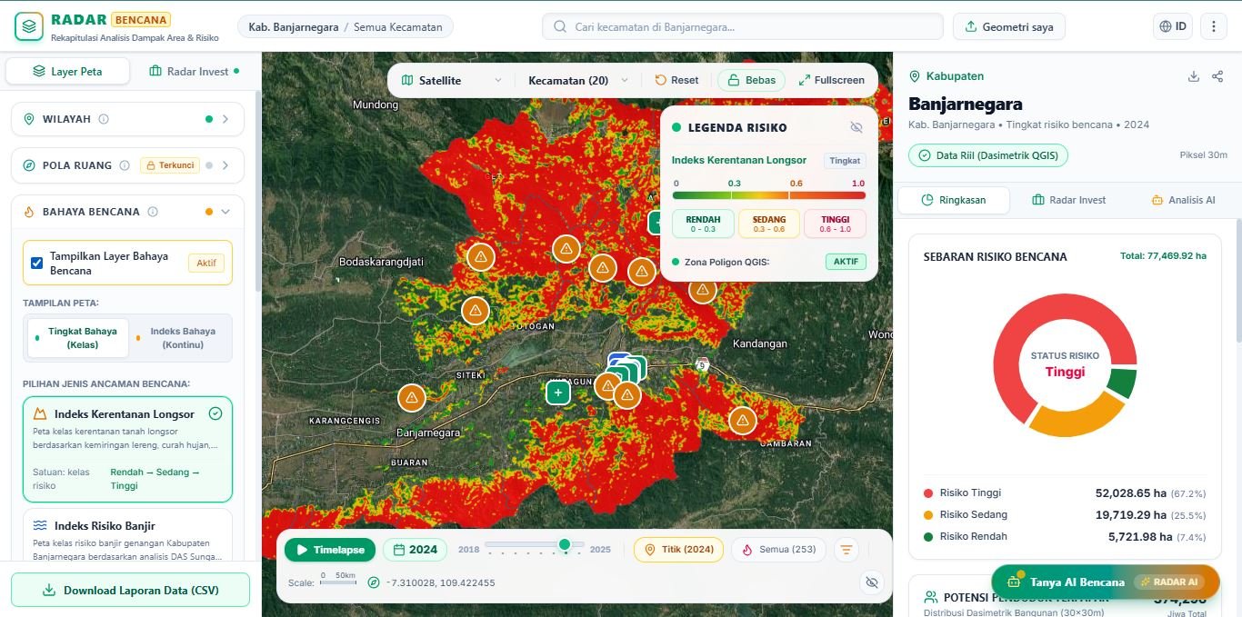
Conversational Geo AI Assistant
Inquire about land asset status, hazard exposure, or canopy metrics in plain language. The AI instantly aggregates multidimensional satellite layers into crisp figures and concise summaries.
Automated Executive Charts & KPIs
Translates millions of satellite pixels into breakdown donut charts, automated hectare totals, and impact metrics ready for executive boardrooms, ESG audits, or donor reviews.
Universal Stakeholder Access
(Zero Learning Curve)
Built for teams across all organizational levels, from executive management to field officers. Accessible directly through any web browser on laptops or tablets without desktop software setup.
Why We Started
Traditional spatial data workflows often remain confined to specialized GIS teams, even though strategic decisions need to be made promptly by executive managers, public officials, and project coordinators.
InklusiGeo.id was formed to address that disconnect. We process satellite archives and remote sensing feeds into practical, intuitive formats that non-technical decision-makers can interpret immediately.
Today, we support government bodies, private enterprises, and institutional donors with verified land cover monitoring, hazard risk assessment, and program evaluations backed by auditable field data.
Inclusive
Solutions tailored to actual partner budgets without the weight of costly perpetual software licenses.
Scientific Rigor
Fusing cutting-edge Geo AI algorithms with localized ground verification for audit-proof accuracy.
Sustainability
Dedicated to disaster risk reduction, ecosystem rehabilitation, and national climate milestones.
Collaborative
Comprehensive technical handholding from scoping to deployment and local team empowerment.
Let's Discuss Your Spatial Agenda
Planning a field monitoring framework, donor-funded conservation mapping, or climate resilience dashboard? Schedule an exploratory scoping discussion.
Registered Office
Sokayasa, Banjarnegara District, Banjarnegara Regency, Central Java 53416, Indonesia
Official Email
WhatsApp Business
Direct Consultation • Fast Response
Technical Scoping Request
Submit your program parameters and our spatial specialists will provide initial scoping within 24 business hours.